


-
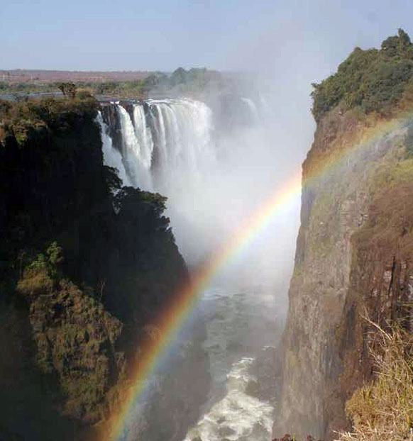 The Victoria Falls, viewed from the western end.
 -
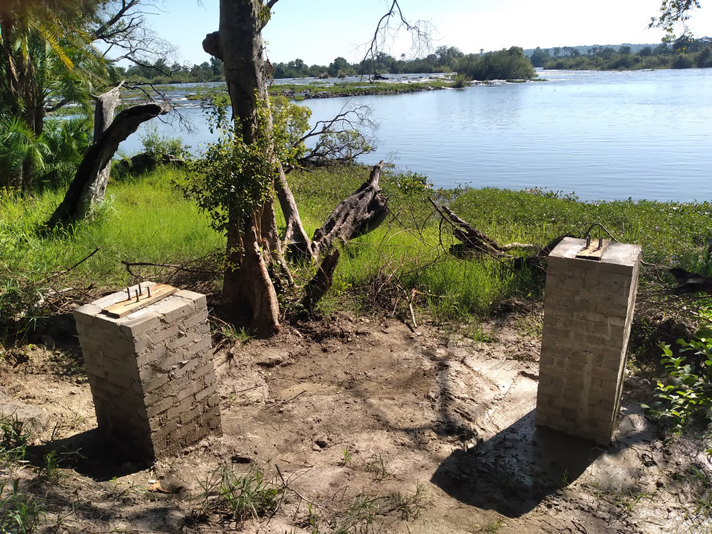 Site of riverside restaurant construction (January 2023).
 -
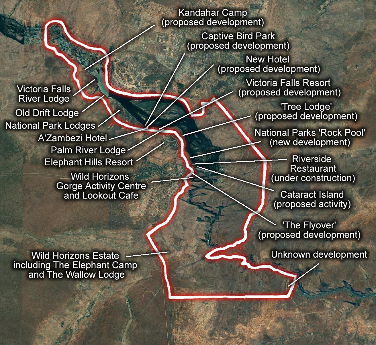 Sketch outline of World Heritage Site boundary superimposed over satellite image and showing the location of existing and proposed developments in the south bank upper river corridor of the World Heritage Site (Satellite image: Google Maps).
 -
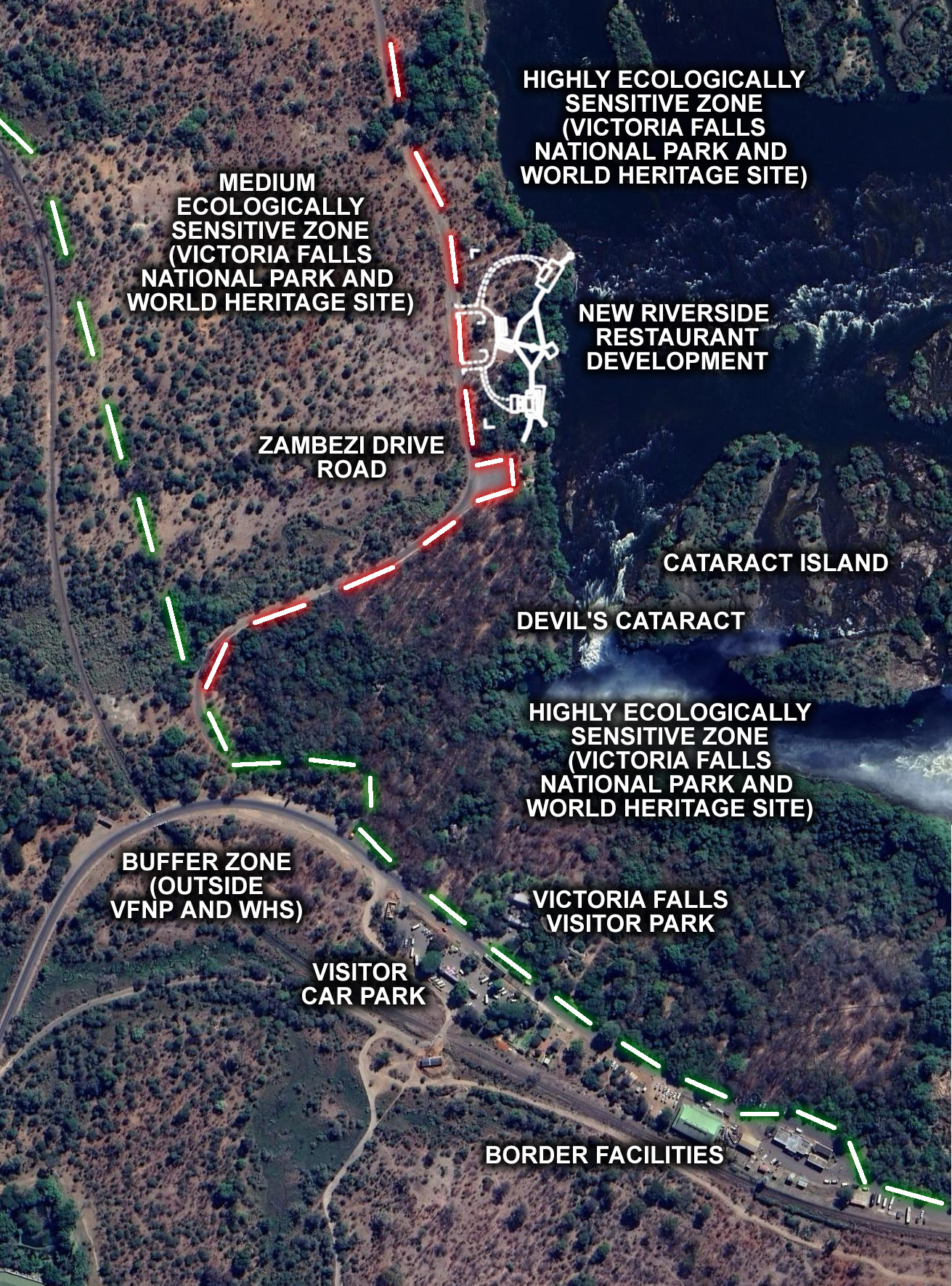 Map showing boundary line of Victoria Falls National Park and site of riverside restaurant development (Satellite image: Google Maps).

The report calls for an immediate halt to construction of the riverside restaurant and ‘tree lodge’ developments, all impacts on the sites mitigated and their lease concessions with National Parks rescinded, and further recommends that the World Heritage Committee requests a total moratorium on all developments in and surrounding the WHS.
A new independent report produced for Keep Victoria Falls Wild highlights urgent concerns over the management of the Victoria Falls World Heritage Site (WHS) and recent allocation of leases and concessions by the Zimbabwe Parks and Wildlife Management Authority, threatening the vulnerable riverine fringe along the upstream river corridor above the Victoria Falls.
A series of new tourism developments have been authorised within the ‘Highly Ecologically Sensitive Zone’ of the Victoria Falls National Park (VFNP), a long-standing ‘no new infrastructure’ zone, including a proposed riverside ‘tree lodge’ development (a significant new 57-room development on a 40 hectare concession stretched along the riverside fringe within the VFNP and already widely promoted within the tourism industry) and a riverside restaurant development (currently under construction immediately above the Falls).
There are also concerns over the allocation of Zambezi National Park Kandahar Camp for development as a lodge concession as this site is also recently identified in management documents as within the ‘Highly Ecologically Sensitive Zone.’
The report calls for an immediate halt to construction of the riverside restaurant and ‘tree lodge’ developments, all impacts on the sites mitigated and their lease concessions with National Parks rescinded, and further recommends that the World Heritage Committee requests a total moratorium on all developments in and surrounding the WHS until suitable management plans and maps are in place and agreed by all parties and all issues relating to the World Heritage Site management zone boundaries are confirmed and clarified.
Conservation Concerns
The riverine forest fringe is a protected feature of the WHS and noted for its importance to wildlife and wider scenic value. The vulnerability of this habitat is also recognised in the 2016-2021 Joint Integrated Management Plan:
“The Zambezi River, in common with all rivers in tropical Africa, has a distinct fringing vegetation of gallery or riparian woodland. The Riverine Forest is found along the banks of the Zambezi, Songwe and Maramba Rivers and on some islands. On the riverbanks it is with a width rarely more than 20-100m wide from the high water mark (Fanshawe, 1975, Meynell et al., 1996). At its best development, riparian forest is a three storeyed forest with a closed evergreen canopy attaining 21m in height… This habitat houses the highest concentration of animals and is the most sought and threatened by human developments.” (State Parties, 2016, p.18-9)
The draft Management Plan, circulated in November 2022, identifies the forested riverine fringe as being particularly at risk from tourism developments, the river, islands and gorges, together with the springs and drainage lines which flow into the river, being under very high risk from development (ZPWMA, November 2022, p.19). Yet despite the vulnerability to this habitat being widely recognised in management documents, tourism developments continue to impact and threaten the river corridor, especially in the upstream section of the site, the draft report of the recent Reactive Monitoring Mission concluding:
“For the area upstream from the Falls, the mission observed that the rationale for the 1989 recommendation to focus on the riverine strip of the National Parks remains justified, with most pressure actually felt by the NP areas near the river that are most relevant to the integrity of the site. While MoTNP and ZNP have been identified as buffer zones, the tourism developments have shown that the status of National Park has not provided the envisaged protection” (UNESCO, 2022).
Zoning Issues
The text of the 2007-12 JIMP clearly identifies the riparian vegetation above the Victoria Falls as within the ‘Highly Ecologically Sensitive Zone’ (State Parties, 2007, p.39). The supporting map (State Parties 2007, p.38) is unclear in showing the zonation of the property in the upstream river corridor.
The 2016-21 JIMP detailed revised zones for the property, although the text description again indicates that the riverine vegetation is included in the ‘Highly Ecologically Sensitive Zone’ (Block 6) and is described as “…following the Victoria Falls Rainforest, thence up the Zambezi River covering the riverine vegetation strip to where it joins the Zambezi National Park boundary” (State Parties, 2016, p.29).
The 2016-21 JIMP identifies the boundary with ‘Medium Ecologically Sensitive Zone’ (Block 7) as extending along Zambezi Drive road.
“The zone covers the Victoria Falls border and the Rainforest car park area and continues from the Victoria Falls Rainforest VIP entrance gate, thence along the Zambezi Drive Road to beacon R11, thence westwards following the boundary beacons to where it joints Zambezi National Park boundary” (State Parties, 2016, p.29).
This clearly indicates that the ‘Highly Ecologically Sensitive Zone’ includes the entire area of the land between Zambezi Drive road and the river – the area commonly known as the riverine fringe or strip – extending along this whole section of the river immediately above the Falls. This interpretation is also consistent with the historical management of this area which has been part of a strict ‘no new infrastructure’ policy since its management was taken over by National Parks in the early 1950s.
It follows that the land from the road away from the river is considered to be within the ‘Medium Ecologically Sensitive Zone,’ an area which is described in the 2016-21 JIMP as including the road and rail transport corridor which dissects the site below the Falls.
The supporting map presented in the 2016-21 JIMP (State Parties, 2016, p.27) confuses the issue by not clearly showing the line of the river above the Falls and appears to incorrectly show the riverside fringe within the ‘Medium Ecologically Sensitive Zone’ (yellow area). The confusion, or error, is more clearly apparent in the map presented in the 2012 Retrospective Inventory (Image 6), which while clearly indicating the line of the river and area of the upstream riverine fringe covered within the VFNP and WHS, mistakenly identifies the area as being in the ‘Medium Ecologically Sensitive Zone,’ an error which is repeated in the most recent map of the property, presented in the 2021 State of Conservation Report (State Parties, 2021, Appendix 2a, p.2).
We believe that all these maps are clearly incorrect in not showing the area of riparian fringe as protected within the VFNP and WHS as being within the ‘Highly Ecologically Sensitive Zone,’ as indicated by the text of the JIMP documents. For this section of the riverine fringe to be in anything other than the ‘Highly Ecologically Sensitive Zone’ would be a significant shortcoming in the administration and management of the site. For it to be within the ‘Medium Ecologically Sensitive Zone’ – the same zone as the rail and road transport corridor and visitor car parking area – would be a serious neglect of Parks core conservation aims and its international obligations under the 1972 World Heritage Convention.
It should also be noted no management zonation is detailed for the upstream area of the ZNP which is included in the WHS in either of the JIMP documents – a significant omission which subsequently allowed the development of two lodges along this section of riverine fringe, the Victoria Falls River Lodge (opened in 2012) and the Old Drift Lodge (opened in 2018). Although the river upstream to Kandahar Island is identified as being within the ‘Highly Ecologically Sensitive Zone’ (State Parties 2007, p.39) this still did not prevent the development of lodge units on Kandahar Island (opened in 2017, part of the Victoria Falls River Lodge development). The revised zonation map subsequently presented in the 2021 State of Conservation Report shows the whole WHS area of the ZNP within the ‘Highly Ecologically Sensitive Zone’ (State Parties, 2021).
The 2016-21 JIMP also presented revised guidelines for permitted activities and developments allowed within the management zones. The original 2007-12 JIMP prohibited all new infrastructure developments (with the exception of existing facilities) the both the High and Medium management zones (State Parties, 2007, p.39-41). The 2016-21 JIMP, while still prohibiting all new infrastructure development within the ‘Highly Ecologically Sensitive Zone,’ permits the development of ‘semi-permanent facilities’ within the ‘Medium Ecologically Sensitive Zone’ (State Parties, 2016, p.32).
Urgent Implications
The errors and discrepancies shown in the management zonation maps are of particular concern in relation to three developments along this stretch of the river – the riverside restaurant (with on-site construction well under-way), the new National Park structure (constructed in early 2022) and the proposed riverside ‘tree lodge’ (again with preparatory work already underway on the ground). The developers of the riverside restaurant are falsely claiming that their site is located within the ‘Orange’ (Medium) management zone and therefore an allowable development.
As it appears certain that the area of the VFNP upstream river corridor and riverine fringe is within the ‘Highly Ecologically Sensitive Zone’ which prohibits all new infrastructure construction there must be an immediate halt to construction of the riverside restaurant (and also by implication the ‘tree lodge’ development), all impacts on the sites mitigated and their lease concessions with National Parks rescinded.
There are also questions over the allocation of Kandahar Camp for development as a lodge concession as the 2021 State of Conservation zonation map shows this site within the ‘Highly Ecologically Sensitive Zone’ – where no new infrastructure or facilities are allowed.

Tatiana is the news coordinator for TravelDailyNews Media Network (traveldailynews.gr, traveldailynews.com and traveldailynews.asia). Her role includes monitoring the hundreds of news sources of TravelDailyNews Media Network and skimming the most important according to our strategy.
She holds a Bachelor's degree in Communication & Mass Media from Panteion University of Political & Social Studies of Athens and she has been editor and editor-in-chief in various economic magazines and newspapers.